
Procedural generation
Creator builds a whole world from two numbers, a size and a seed, by running Rust’s own generation passes in the game’s own order. You get terrain, biomes, topology, ground textures, monuments, roads, rivers, rails, powerlines, rocks and foliage, in one run, with nothing to place by hand.
Generate one from the start screen
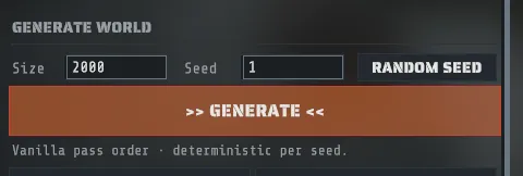
Section titled “Generate one from the start screen”- Find the GENERATE WORLD section on the start screen.
- Type a Size. Anything from 1000 to 6000, in meters along one edge.
- Type a Seed. Any whole number from 0 upwards, or press RANDOM SEED beside it to pick one you can still edit.
- Press >> GENERATE <<.
The line under the button says what you are getting: “Vanilla pass order · deterministic per seed.”
If either field is unusable the button stays disabled and the message tells you which one and why, for example “Map size must be between 1000 and 6000 (you typed 200).” Nothing falls back to a default size behind your back.
Size decides more than how far you walk. Rust skips whole generation passes below certain sizes, so a small map has no road ring and no mountains no matter which seed you pick. The thresholds are on How Rust builds a map.
While it runs
Section titled “While it runs”Generation takes minutes, and the loading screen is built so you can tell working from stuck. It comes up the moment you start the run, shows the pass that is running by name, its position in the ladder, a progress bar, an elapsed clock, and the seed and size you asked for, and stays until the map is finished.
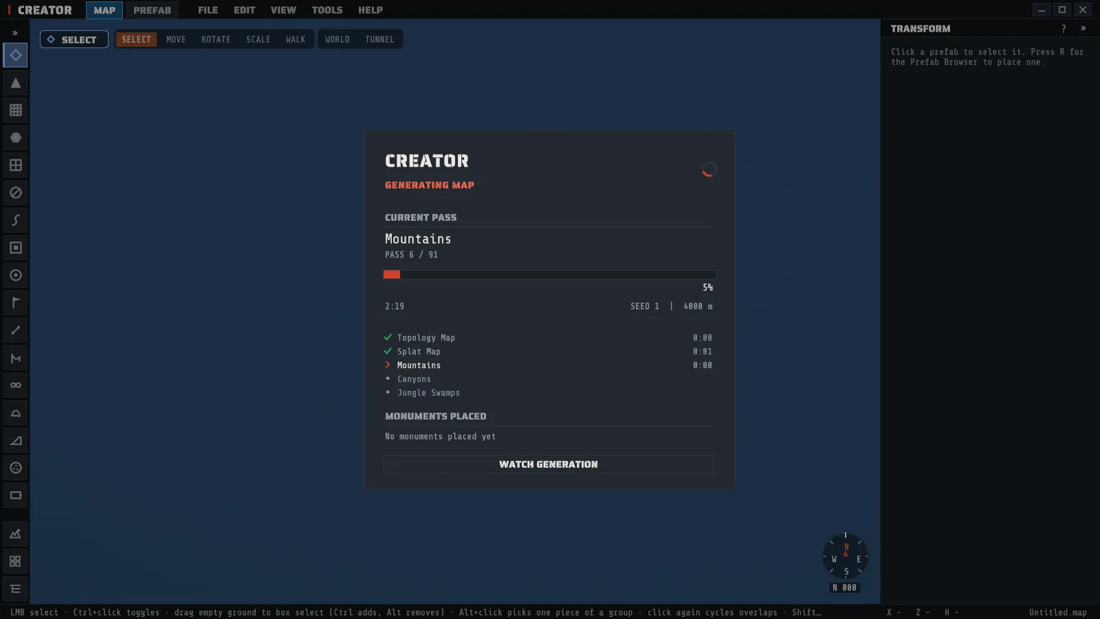
- The bar moves at pass boundaries, not smoothly. A heavy pass holds one name for minutes. That is normal.
- The spinner and the clock keep moving regardless. They are what tell you the run is alive.
- MONUMENTS PLACED lists the monuments as they land: how many so far, and the newest five with the time on the run’s clock at which each one landed and the family it belongs to. A seed that will not give you the monument you want shows it here long before the run ends.
- WATCH GENERATION shrinks the overlay to a small pill in the corner, showing the percentage, the current pass and how many monuments have landed, so you can watch the world being built. Click the pill to bring the full overlay back. You can fly the camera while you watch, but editing waits until the map finishes generating: a click or an edit key in the world does nothing, and a message says so the first time.
- CANCEL is in the full overlay. A generation you started yourself can always be canceled. It asks first, and the question says what happens to the map: from the start screen the partly built map is discarded and you go back to the start screen, in a queue the queue ends too and the maps it already kept stay, and from the Procedural Generation panel the map stays as it is now, part built, with Undo putting back the map you started from (or, when Creator could not store a copy of it, a plain warning that this cannot be undone). The run stops inside the pass that is running. When that pass is reading one of Rust’s scenes the card says Stopping: finishing the scene it is reading until the scene is done.
- You do not have to watch. When a generation of a minute or more, or a queue, ends while you are in another window, Creator’s taskbar button flashes until you come back, and a notice in the app says what finished. Flash the taskbar when a generation finishes in Preferences turns that off.
Why it takes as long as it does, and what to do about it, is in the FAQ.
The run report
Section titled “The run report”Every generation leaves a report of what it did. When you save the map, Creator writes the report beside it as
<map name>.report.json. The report says:
- What was asked. The size, the seed, the settings the run was given, and the Rust content it ran on.
- What was placed. Every monument family with how many of it the map holds, and how many roads, trails, rails, rivers, powerlines and bridges were laid. A monument you swap for a pack is no longer on the map, so it is left out of the count, and the report has a line for each swap saying how many were swapped and for which pack.
- What was not, and why. A family that placed nothing says why: Rust does not place it on a map that small, its component was not ticked, the settings asked for none, or Rust’s placement rules found no spot on this seed. A run that stopped early lists the families it never got to apart, as not reached, so they are not read as families Rust could not place. Anything the settings asked for that the run could not do in full (fewer rivers or oil rigs than asked, a swap that found no monument) is listed with what to change. A second run on the same map reports only its own shortfalls, never the run before it.
- Why spots were turned down. Rust tries thousands of spots for each monument and turns most of them down. Each family lists its three most frequent reasons with how many spots each one cost, in plain words: too close to another monument, outside the biomes and ground the monument may stand on, in the wrong tier of the map, on ground too uneven for it to sit on, where a part that must stand in water was on dry ground, and so on. A harbor that never appears on your seeds is usually explained by the top line. The counts are spots tried, not monuments lost: a family that placed everything it could still turned many spots down on the way.
The report is written once per save, next to the file you saved, and it follows a Save As to the new name.
It describes the generation, not the edits you made afterwards. A map you opened from a file gets no report,
because no generation in this session made it. A queue keeps the same detail for
every seed in its queue.json, so a queue’s folder holds one record and no per-map report.
The run summary
Section titled “The run summary”When a generation you started finishes, the RUN SUMMARY window opens over the new map. It is the run report on screen: the seed and size, how many monuments the map holds by family, how many roads, rivers and other paths were laid, which families placed none, and anything the settings asked for that the run could not do.
Screenshot: the RUN SUMMARY window after a generation: the seed and size, how many monuments by family, the paths, the families that placed none, and SHOW DETAILS open on the reasons spots were turned down. (
images/run-summary.png)
- SHOW DETAILS lists every monument family on its own line: what it placed, or why it placed none, and the most frequent reasons Rust turned spots down for it.
- TOOLS > Last Run Summary…, or LAST RUN SUMMARY under Generate several, brings the window back. It keeps the last generation of the session, including one that was stopped for a required monument, so you can read why the monument found no spot on that seed. The notice a stopped run shows says the same reasons in one line, from the start screen as from the panel.
- RUN SUMMARY and QUEUE RESULTS are two windows, so reading one run’s summary leaves a queue’s results open.
- The window does not open for a generation started from the command line or a capture. Show the run summary after a generation in Preferences turns the automatic opening off; the button still works.
A queue’s QUEUE RESULTS window shows the same lines on each seed’s row, with the same SHOW DETAILS.
The same seed gives you the same map
Section titled “The same seed gives you the same map”Generation is deterministic: the same size and the same seed produce an identical world, every time, on any machine. That is Rust’s own behavior and Creator keeps it.
With one condition, and it is the one thing on this page worth remembering:
A seed reproduces a map only against the Rust build it was generated on.
If you care about reproducing a map later, write down the size, the seed and the snapshot build id together. Two of the three are not enough.
Required monuments
Section titled “Required monuments”A map’s settings can name monuments the map must have. Creator then stops a generation that will never place one, at the step that decides it, so you do not wait for a map you would throw away.
- Required means placed by Rust’s own rules. Nothing is forced. No spacing, terrain or biome rule is relaxed to make a required monument land: a seed either gives you the monument or it does not.
- The run stops as soon as it knows. Rust places each monument family at one step of the ladder. When that step ends without the monument, the run ends there, a notice names the monument, and nothing is saved. A required Launch Site is decided before the roads are laid, so a seed without one costs a part of a run, not all of it.
- With every required monument placed, the map is the same map. The same size, seed and settings give the identical world with or without the list, which is why it works in Standard Mode as well as Creator Mode.
- A whole family can be required. “Any harbor” is met by either harbor.
Creator refuses a list that can never be met before anything runs: a required monument you also left out, one outside an only-these-monuments list, one whose component is unchecked, one a blacklist or whitelist removes, one Rust does not place on a map that small, or an oil rig when the oil rig numbers ask for none of its kind. A required family is refused too when your settings rule out every one of its monuments between them, even though no single setting does. The message names the monument and what to change.
Requiring a monument you also swap for a pack is fine: the swap happens after Rust has placed the monument, so the list keeps only the seeds where your pack lands.
Set the list where you generate:
- On the start screen and in the Procedural Generation panel, open Generate several and press ADD REQUIRED. Pick a monument by name, or a family as Any of Harbors. Each one you pick shows as a chip with an x that takes it off again. The list applies to a single >> GENERATE << or RUN too, not only to a queue.
- In Creator Mode, the MONUMENTS section has a star beside every monument and every family. Click a star to require it; click it again to clear it. The stars and the chips are one list. A monument you untick cannot be starred, and unticking a starred one clears its star.
- An assistant sets the same list as
monuments.required.
When a single run from the panel stops for a required monument, a notice names it and offers TRY ANOTHER SEED, which takes the stopped run back and picks a new random seed. It does not start a run: open Procedural Generation and press RUN to generate with the new seed.
Pressing CANCEL is never read as a missing monument, even during the step that decides one: the run is canceled, not stopped. A run with TICK THE LAND ONLY set places no monument, so it does not require any: the confirm says so, and your stars stay for the next full run.
Generating several maps
Section titled “Generating several maps”One setup, several seeds: Creator generates the maps one after another, saves each one it keeps with a picture, and shows you the list at the end so you can open the one you like. With a required monument set, a seed that does not place it is stopped early and the queue moves on to the next seed.
- On the start screen under GENERATE WORLD, or in the Procedural Generation panel, open Generate several.
- Set Maps, from 1 to 20, and choose Seeds: Random seeds, Count up from the seed (the Seed field above is the first), or These seeds with your own Seed list, separated by commas.
- Optionally set Stop after to end the queue once that many maps were kept (0 runs every seed), give the queue a Queue name, and add required monuments.
- Press >> GENERATE SEVERAL <<. The line above the button says what will happen before you press it.
- Where the maps go. A new folder named after the queue, in
Documents\Creator\Maps. It holds each kept map, a picture of each, andqueue.json, the queue’s own record: the seeds, the settings, and one row per seed with everything a single run’s report holds. A queue never overwrites a file, its record included: a folder an earlier queue used getsqueue (2).json. - What each seed can end as. Kept: the map finished and was saved. Stopped: a required monument was not placed, and nothing was saved. Failed: something went wrong in that run, and the queue went on to the next seed. Not started: Creator could not start the run (its land could not be used, or Rust was updated while Creator was open), the row says why, and the queue ends there. Canceled: you pressed CANCEL, which stops that run and the rest and keeps every map already saved.
- A map that is not server-ready is kept, and flagged. Each kept map is checked the way the server-readiness check does, and its row says the result, so a map that is one fix away is not thrown out.
- When the queue ends, the first map it kept opens and the QUEUE RESULTS window lists every seed. OPEN MAP opens another map of the queue (it asks first if you have unsaved changes), SHOW IN FOLDER opens the folder, and REMOVE MAP deletes one map’s files (the map, its picture, its recipe file and its server settings file) after asking. LAST RESULTS in the block brings the window back. A seed’s row says why a stopped seed stopped, lists the families it never got to apart from the ones that placed none, shows a note about something the run could not do in the warning color, and shows a map that is not server-ready in red.
- A queue started from the panel replaces the map that is open with whole new maps, and asks before it does. It cannot keep the open map’s layers, so in Standard Mode every Terrain row must be checked.
- One map is in memory at a time, so a queue needs no more memory than a single generation. Creator ends the queue with a clear reason, keeping every map made so far, if its memory keeps growing, if the PC is running out, or if the disk is nearly full.
Generating onto a map you already have
Section titled “Generating onto a map you already have”The start screen’s button generates a fresh world. Inside the editor you can instead run chosen passes onto the map that is open, which is how you finish a terrain somebody else shaped.
- Open TOOLS > Procedural Generation….
- Check the passes you want. They are grouped as Terrain / Splat, Monuments, Paths / Roads and Rocks / Decor, with ALL and NONE to set the lot.
- Set the Seed on the right, or press RANDOM for a new one.
- Press >> RUN SELECTED PROCEDURAL COMPONENTS <<.
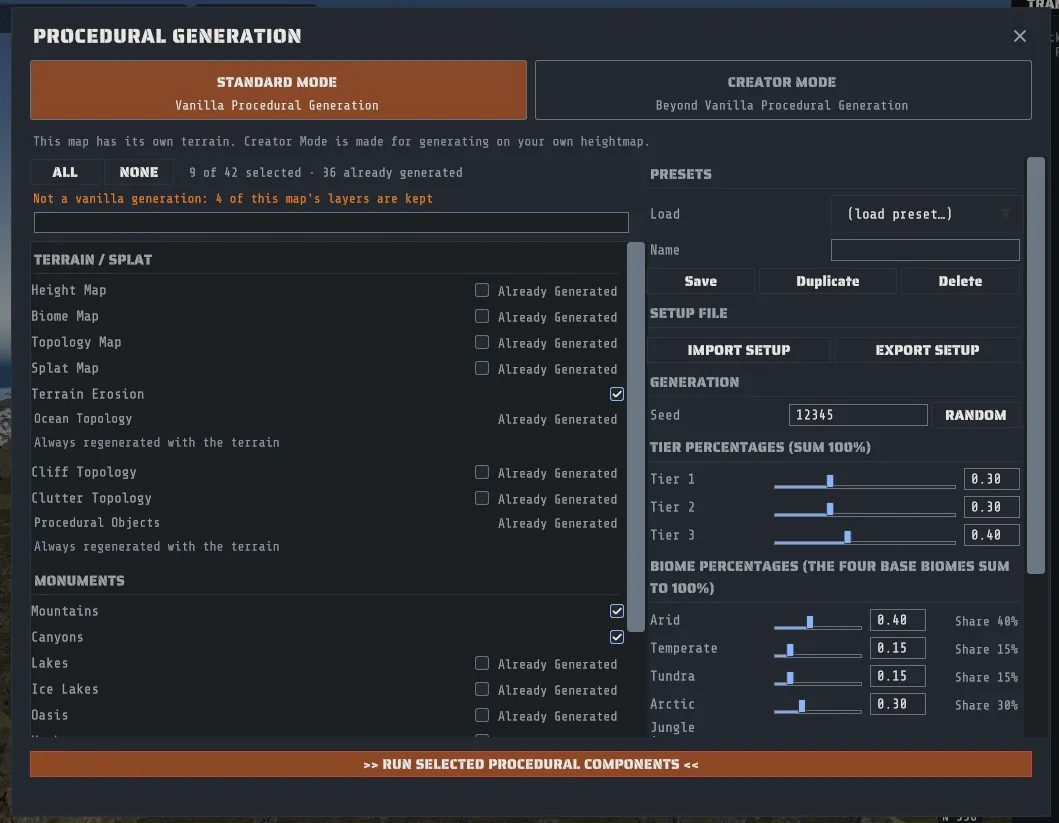
Run only the passes whose content the map does not already have. Running the monument passes on a map that already has monuments gives you two sets, not a better set. The same goes for cliffs, rocks and roads. This is the whole trick to finishing a Crucible Heightmap island, and the panel now does most of the work of getting it right for you.
Standard Mode and Creator Mode
Section titled “Standard Mode and Creator Mode”The top of the panel is a switch with two sides, and it stays in view however far you scroll.
- STANDARD MODE, Vanilla Procedural Generation, is Rust’s own generator and nothing else. With Height Map, Biome Map, Topology Map and Splat Map all checked, a run on a new blank map gives you the same map a Rust server builds from that size and seed. You can still uncheck a terrain row to keep that layer (see below), and when you do, one line under ALL / NONE says Not a vanilla generation (hover over it for which layers are kept and why), and the confirm dialog says so too.
- CREATOR MODE, Beyond Vanilla Procedural Generation, is for generating on a heightmap you bring, with the monuments you choose and, when your land is a group of islands, bridges and one road around them. The window’s outline turns red, a CREATOR MODE badge appears beside the title, and the run button reads >> RUN IN CREATOR MODE <<, so the mode is plain without relying on color. The confirm dialog opens with “Creator Mode: this map will not be a vanilla generation.” and then names the land, how many monuments are left out (and, when you changed any, how many families have a changed count), how many are pinned, and whether bridges are on.
The panel opens in Creator Mode when the map that is open already goes beyond vanilla, and in Standard Mode otherwise. It opens in Creator Mode when:
- the map was made in Creator Mode, or its recipe uses a Creator setting (your own heightmap, an island layout, bridges, monument pins, monuments left out, or the Tropical biome). It opens with that map’s settings.
- the map has terrain of its own that is not shaped like Rust’s own island. Rust’s island is always one landmass over the middle of the map with open sea to every edge, so the panel opens in Creator Mode when land reaches the map edge, when the land is several islands, when the land is off the map’s middle, or when the terrain has no island at all. A few small islets off the coast, as Rust’s own maps have, do not count.
When it opens in Creator Mode for one of these reasons, one line under the switch says why, for example “Opened in Creator Mode: land reaches the map edge; the land is several islands. Rust’s own island is one landmass over the map’s center, with open sea to every edge.” A new blank map, and a map shaped like Rust’s own island, open in Standard Mode. On a map that has terrain of its own, Standard Mode shows one line under the switch: “This map has its own terrain. Creator Mode is made for generating on your own heightmap.”
You can always switch, and your choice wins: once you pick a mode on a map, the panel opens in that mode every time you open it again on the same map, whatever it would have chosen. Opening or creating another map starts from the rule above again. Loading a preset counts as your choice too.
Switching is instant and runs nothing. Anything you set in Creator Mode is kept when you switch back to Standard, and the footer says so, but a Standard run does not use it. That includes a map you saved from a Creator run: pressing RUN in Standard Mode on it generates Rust’s own island, with no bridges and no monuments left out, whatever the map’s recipe says.
A Creator Mode run also changes three small things Rust’s own generator does, with no setting of their own:
- Unbroken trails. Every dirt trail gets a full-strength dirt line down its middle, so a trail on a large map does not break into dashes.
- No poles on another road. A telephone pole or roadside object beside one road is never placed on another road’s surface, or within a meter of its edge, where two roads meet.
- Icebergs near the coast. A few icebergs are kept, the ones nearest the coast first, and none more than 300 meters from land. On a map with wide sea between its islands, Rust’s own rule would scatter them across all of it.
The GENERATE WORLD button on the start screen is always Standard Mode. To start a Creator Mode map from nothing, press CREATE BLANK at the size you want, then open TOOLS > Procedural Generation…. Each Creator section starts closed; click its heading to open it, and it stays open the next time. What each Creator section does is in Generating on your own heightmap below.
The panel knows what your map already has
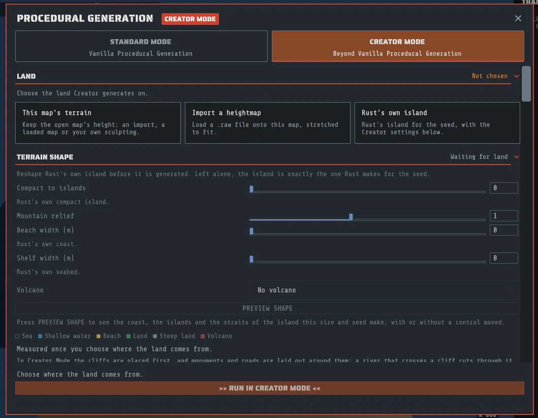
Section titled “The panel knows what your map already has”Components your map already has are marked Already Generated.
- A component your map already has is marked Already Generated, and it starts unchecked.
- Everything else starts checked, exactly as before.
- Tick a marked row back on and Creator asks first: “This map already has Height Map. Generating it again replaces it. Continue?” Press CONTINUE to tick it or GO BACK to leave it unticked. It asks once per component while the panel is open, not every time you click, and ALL asks once for every marked row.
- The count beside ALL / NONE reads, for example, 38 of 42 selected · 5 already generated.
So on a map you imported, pressing >> RUN SELECTED PROCEDURAL COMPONENTS << straight away adds what the map is missing and leaves what it has, which is what you almost always want. On a map you just created there is nothing in it yet, so nothing is marked and nothing changes.
Unchecking a terrain row keeps that layer. The four rows in Terrain / Splat that name a layer, Height Map, Biome Map, Topology Map and Splat Map, are the ones the rest of the run is built on. Leaving one unchecked keeps your map’s own layer and generates everything else from it: with Height Map unchecked, the biomes, topology and ground textures are worked out from your terrain rather than from a shape Rust invented. Unchecking Height Map keeps the map’s water with it, because the two are one thing.
Some rows have no checkbox. A few components are part of building the terrain and cannot be run or skipped on their own, so instead of a box they say Always regenerated with the terrain. A checkbox that did nothing would be worse than none.
Undoing a generation
Section titled “Undoing a generation”A generation you start from this panel is one undo step. Ctrl+Z puts the previous map back, terrain layers, prefabs, paths and all. Redo brings the generated map back. This works for a run you cancel half way too.
A generation replaces the ground, so any live paths on the map are baked into what the run starts from, and the confirm says how many. Undoing the generation brings them back, live, with the map. Importing a heightmap and the land fixes below bake the live paths and ramps that shape the height the same way, inside their own undo step (FILL THE HOLLOWS only those whose ground lies around the hollows), and say how many they baked.
The confirm dialog, GENERATE MAP, has two buttons: CONTINUE starts the run and GO BACK returns to the panel without running anything. It tells you which way the undo is going to be, so read that line:
- “Generating replaces the current terrain; UNDO restores it.” Ctrl+Z works.
- “Generating replaces the current terrain and every edit, and CANNOT be undone.” The reason is in brackets after it.
Putting a map back is a full reload, so on a large map it takes as long as opening one does. And the generation from the start screen is not undoable at all: there is no earlier map to go back to, because that run made the map.
The controls on the right
Section titled “The controls on the right”| Control | What it does |
|---|---|
| STANDARD MODE / CREATOR MODE | The switch at the top of the panel, described above. Every control in this table is in both modes. |
| Seed | The seed the selected passes run with. RANDOM picks one for you. |
| Tier Percentages (sum 100%) | How the map’s area is split across the three monument tiers: Tier 1, Tier 2, Tier 3. Normalized to 100% for you. |
| Biome Percentages (the four base biomes sum to 100%) | The weight of each base biome: Arid, Temperate, Tundra, Arctic, kept at 100% together as one moves. Jungle is separate: it replaces part of the Tier 0 biome, the way a Rust server’s own setting does, and moving it changes nothing else. The defaults are a Rust server’s own (Jungle 0.50). |
| Biome preset | Creator Mode only, above the biome sliders: Vanilla (Rust’s own weights), Winter, Arid or Jungle sets the five weights at once. Moving a slider afterwards makes them your own, and the dropdown then reads Custom. |
| Prefab Filters | Blacklist and Whitelist, described below. |
| Presets | Save the whole panel under a name, or load one of yours or one that comes with Creator, described below. |
The blacklist and the whitelist
Section titled “The blacklist and the whitelist”Both fields take a list of text fragments, separated by commas or semicolons, and both are matched against the prefab’s own path, case insensitively, as a substring.
- A prefab whose path contains any Blacklist fragment is never placed.
- If the Whitelist is empty, everything else is allowed. If it has anything in it, only prefabs matching one of its fragments are allowed.
- The blacklist wins: a prefab matching both is excluded.
So oilrig, cave keeps oil rigs and caves off the map, and a whitelist of rock generates a map of nothing
but rocks, which is occasionally useful and mostly a good way to see what a pass does.
You do not have to type a path. In the Prefab Browser, highlight a prefab and press ADD TO BLACKLIST under its preview: its whole path is added to the end of this panel’s Blacklist, which blocks that one prefab and nothing else. Save a preset to keep the list for the next launch. Copy Prefab Path, on the right-click menu over a placed prefab, puts a path on the clipboard to paste here.
Presets
Section titled “Presets”A preset is a named snapshot of the whole panel: the seed, the tier and biome percentages, which passes are checked, both filters and the mode. A preset saved in Creator Mode also keeps the Creator settings: the monuments left out, the pins, the island share, the bridge settings (the river crossings you chose to bridge included), the oil rigs and the river settings. Where the land comes from is not in a preset, because it belongs to the map that is open. Loading a Creator preset switches the panel to Creator Mode. A preset saved before the switch existed loads in Standard Mode.
- Type a name in Name.
- Press Save.
- Load it later from the Load dropdown. Duplicate copies the current state under a new name, and Delete removes the selected preset.
Presets are kept between sessions.
Presets that come with Creator
Section titled “Presets that come with Creator”Creator comes with six presets of its own, listed under Shipped presets, each marked (shipped). They cannot be changed or removed, and a preset of yours cannot take a name ending in “(shipped)”.
| Preset | What it sets |
|---|---|
| Vanilla | Rust’s own generation, every setting at the game’s default. Pick it to set the seed, the percentages, the filters and the passes back to Rust’s own. |
| Winter | The Winter biome weights: more Arctic and Tundra, no Jungle. |
| Arid | The Arid biome weights: mostly desert, little snow. |
| Jungle | The Jungle biome weights: more Jungle over the warm biomes. |
| Arena 1000 m | A 1000 m map, Rust’s own generation, nothing else changed. |
| Arena 2000 m | A 2000 m map, Rust’s own generation, nothing else changed. |
All six are Standard Mode on Rust’s own island, every pass checked, seed 1. The biome weights are the same ones the Creator Mode Biome preset dropdown sets.
- In the Procedural Generation panel, pick one under Shipped presets, below Load. It becomes the panel’s state as an imported setup does, seed included. A run from the panel uses the open map’s size, so a preset written for another size says so.
- On the start screen, pick one under Shipped presets, above IMPORT SETUP. It is held as an imported setup is held: its size and seed fill the fields, and >> GENERATE << runs it. This is how an arena preset generates at its own size. CLEAR SETUP lets go of it.
Setup files: moving a setup between machines
Section titled “Setup files: moving a setup between machines”A setup file is the whole generation setup as one small file: the size, the seed, the mode and every setting. Send it to someone, keep it beside a map, or carry it to another PC.
- EXPORT SETUP writes the setup you have on screen to a file you name. On the start screen that is the size, the seed and the required monuments (and the setup you imported, if you hold one). In the Procedural Generation panel, under SETUP FILE, it is everything the panel is set to, Creator Mode sections included.
- IMPORT SETUP reads one back. Nothing is generated: you still press the button.
- On the start screen the setup is held. Its size, seed and required monuments fill the fields, where you can still change them, and >> GENERATE << and >> GENERATE SEVERAL << run it. The line under the buttons names the file, and CLEAR SETUP lets go of it.
- In the panel the setup becomes the panel’s state: the seed, the percentages, the filters, which passes are checked, the mode and the Creator Mode sections. A run from the panel always uses the open map’s size, so a setup written for another size says so; import it on the start screen to generate at its own size.
- A file Creator cannot read is refused, and nothing changes. The message names what is wrong: a setting this version does not know, a size or seed out of range, or a setup that says Standard Mode while using a Creator Mode setting.
- A setup names a heightmap, it does not carry one. A setup made on a heightmap you imported, or on the terrain of the map that was open, says so when you import it: choose the land under LAND before you run.
A setup file is the same recipe an assistant exports and imports, so the two are interchangeable. With the same Rust content, the same size and the same seed, it generates the same map on any PC.
Generating on your own heightmap (Creator Mode)
Section titled “Generating on your own heightmap (Creator Mode)”Creator Mode runs Rust’s own generation passes over land you bring: a heightmap from World Machine, Gaea, Crucible Heightmap or any other terrain tool, a map somebody sent you, or terrain you sculpted yourself. The biomes, topology, ground textures, monuments, roads, rivers and rail are all worked out from that land rather than from the island Rust would have made for the seed.
Switch the panel to CREATOR MODE and eight sections appear above the component checklist, in this order: LAND, TERRAIN SHAPE, ISLANDS AND ROADS, BRIDGES, RIVERS, MONUMENTS, TROPICAL and DEEP SEA ISLANDS. Each starts closed, with a short summary at the right of its heading (This map’s terrain, Rust’s own island only, 4 islands, On, one loop, Rust’s own rivers, 42 of 42 monuments included, Off, Off); click a heading to open it. LAND opens by itself while no land is chosen, because the run waits on it. The components, seed, percentages, filters and presets below them work exactly as they do in Standard Mode.
LAND: where the height comes from
Section titled “LAND: where the height comes from”Three choices, and the run button stays disabled with “Choose where the land comes from.” until one is picked. On a map that has its own terrain, This map’s terrain is already picked for you.
- This map’s terrain keeps the open map’s height and its water, whatever made them: an import, a loaded map or your own sculpting. Everything else is generated from that height.
- Import a heightmap brings a
.rawfile in from the panel itself, with the same Bit Depth and Byte Order as the Sculpt tool’s import (see Import a heightmap). The file is stretched to fit the open map, the import is one undo step, and afterwards This map’s terrain is picked. The section shows the open map’s size, because a heightmap takes the size of the map it lands on; change the size first in Map Tools if you need to. - Rust’s own island keeps no height: Rust’s island for the seed, with the Creator settings below it. Use it when you want a vanilla island but your own choice of monuments.
While Height Map is decided by LAND, its row in the checklist is locked and says which way it went, for example “Set by Land: this map’s terrain is kept”.
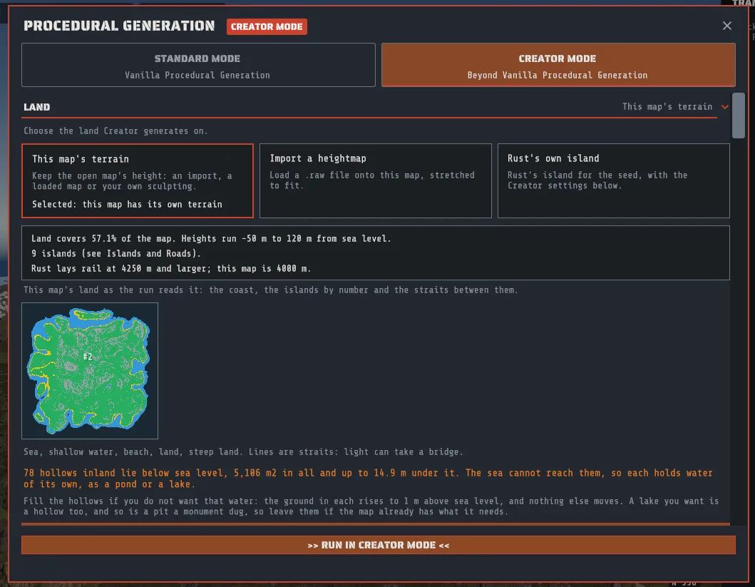
The pre-flight card. Once the land is picked, Creator measures it and prints a short card before anything runs: how much of the map is land and the height range, how many islands it found, and whether this map size carries rail (Rust lays rail at 4250 m and larger). The islands themselves are listed in ISLANDS AND ROADS, largest first, each with a number, its area, the road it can carry (a ring road, a single road across a narrow island, or none for an island too small for a road, just as Rust’s own small islands have none: an island needs at least 0.25 km2 for a road, and a map needs to be 4000 m or larger for island roads at all) and whether it joins the map’s mainland; the straits between the islands large enough for a road are listed in BRIDGES, narrowest first, each with its width and whether a bridge can span it. The island numbers are the ones every section uses, so a pin names island #2 and means the island listed as #2. MEASURE AGAIN re-reads the land after you change it.
The picture under the card. For This map’s terrain (and for a heightmap you have just imported, which becomes it) the card is followed by a small map of the land as the run reads it: the deep sea dark, shallow water blue, the beach amber, land green and land too steep for a road gray, each island that is large enough for a road numbered, and a line across each strait between those islands, light where a bridge can be built and red where it cannot. It is the same picture PREVIEW SHAPE draws for Rust’s own island, but nothing is predicted here: it is your height as it stands, so it changes when you sculpt and press MEASURE AGAIN, or use one of the fixes below.
When the land is not ready, the card offers the fix, each problem in orange with its fix directly under it. Each fix is one undo step, and the card measures again afterwards.
- Almost all land, or almost all sea. A heightmap exported with its sea at its lowest value reads as one big continent. SET SEA LEVEL picks which height of your heightmap becomes the shoreline (the Shoreline (m) slider) and moves the terrain so that height lands at sea level, with a small map preview of the new coastline before you apply it.
- Land touching the map edge. Rust needs open water around the map for the ocean border and the offshore oil rigs. SINK THE MAP EDGE lowers the outer margin smoothly to the seabed over the width you choose, and leaves the rest of the map untouched.
- Hollows inland below sea level. Ground lower than the sea that the sea cannot reach holds water of its own, as a pond or a lake. The card says how many there are, their area and how deep the deepest lies. FILL THE HOLLOWS raises the ground in each one to 1 m above sea level and moves no other ground (live paths are baked first, as above). Its undo step holds only the area around the hollows, so it costs little of the undo history. Press it for the pits a heightmap from another tool is often full of. Leave it alone for a lake you want, and on a map that already has monuments, because a pit a monument dug is a hollow too. To see which hollow is which, the land picture numbers the largest twelve (H1, H2, …), and the list above the button gives each one’s area and depth with a GO TO that closes the panel and looks at it.
An island too small for a road, or a strait wider than the longest bridge, is not a problem to fix: the island keeps no road and no bridge, and those two islands stay unjoined unless you raise the longest bridge in BRIDGES.
Looking at the land in the viewport before a full run. Once a land is chosen, TICK THE LAND ONLY at the foot of the section unticks every row of the checklist but the terrain ones (the height, biome, topology and ground texture maps, erosion and the cliff and clutter topology). Press >> RUN IN CREATOR MODE << and the run builds the land and skips every row that is now unticked, so you can fly the bare land. Monuments you starred as required are not required on that run, and they stay starred. Then press UNDO to put the map back, ALL to tick every row again, and run the whole generation. If the map already has some of those layers, the button asks once before it ticks them, because ticking a layer regenerates it. On Rust’s own island this is how to see a seed’s island, or the shape TERRAIN SHAPE gives it, in three dimensions before committing to its monuments and roads.
ISLANDS AND ROADS
Section titled “ISLANDS AND ROADS”This section lists the islands the pre-flight measured and is live when it finds two or more islands, or one island with a bay a bridge can cross. On Rust’s own island it explains that there is one landmass and nothing to share.
- What each island gets is shown as a fact rather than a switch: each island large enough gets its own road (a ring, or one road on a narrow island), its share of each monument family and its own rivers. With bridges on and one loop around the islands (see BRIDGES), the loop takes the place of the separate rings. Separate island roads need two or more islands large enough for a road. Land with only one such island, however many small islets lie off it, gets Rust’s own ring road (and on a map of 4250 m or larger Rust’s own rail ring), as Rust’s own island does, unless the island curls round a bay whose mouth a bridge can span: then, with bridges on, the one loop goes round the bay and crosses the mouth on a bridge (see BRIDGES).
- Monument share. By area (preferred) is the default and fills each island to its share. By area (strict) never places more than the share.
- Pins put a monument on the island you choose. Under Pins, choose a Family, optionally one Monument of it, and an Island number from the list above (or Any island), then ADD PIN. A pin moves one of the family’s monuments to that island, from the island holding the most, so it never adds a monument to the map; naming one monument records which one you had in mind. REMOVE takes a pin off.
BRIDGES
Section titled “BRIDGES”This section is live when the land has two or more islands large enough for a road, or one such island with a bay. A bay here is water the island closes round, open to the sea only through its mouth: a cove along the coast is not one, and neither is a lagoon the land closes off from the sea, so neither is offered as a crossing. It lists the crossings between those islands (or the bay’s mouth), narrowest first, and says in plain words what the bridge law will do with the settings you have. Islets are never bridged: an island too small for a road is not in the list and is never joined, however close it lies, and the section says so whenever the land has one. On land with nothing to join, Rust’s own island included, its status line says so and points you at Bridges over rivers further down, which works on any land.
| Control | What it does |
|---|---|
| Build bridges | On by default when the land has a crossing the longest bridge spans between two islands large enough for a road (or across one such island’s bay), off when it has none. A strait to an islet never turns it on. The line under it says which, until you flip it yourself. |
| Island roads | One loop around the islands (the default) or Separate rings, joined by bridges. Both are described below. |
| Rail follows the road loop | On a map of 4250 m or larger, the rail runs as one loop inside the road loop. Off gives each island its own rail ring, joined across the same bridges. Below 4250 m Rust lays no rail at all, and the setting is kept for a larger map. |
| Longest bridge (m) | The widest strait a bridge may span. 300 m by default and never more than 400 m. |
| Deck clearance (m) | How high each deck sits above the water, 15 m by default. The line under it says which boats can pass under. |
| Bridge style | Concrete (one continuous span), the default, or Ferry bridge (one piece per crossing), the game’s own ferry bridge piece. |
| Bridges over rivers | Off by default. On, every crossing of a river by a road or a rail that can take a bridge gets one, in place of Rust’s causeway. It does not need islands: it is live on any land, Rust’s own island included. See “Bridges over rivers” below. |
| Ring road crosses on bridges | On by default, and live while Bridges over rivers is on. Off keeps Rust’s causeway on the ring road alone, which keeps it one closed road. On, Creator writes the traveling vendor a closed road across the decks (see “The ring road and the traveling vendor” below). |
| Allow building under bridges | Off by default. On, players can build in the space under the deck of a bridge between islands, while the deck, its piers and both ends stay no-build. A bridge over a river stands so low over the water that almost no space opens under it. See “Every bridge is a no-build zone” below. |
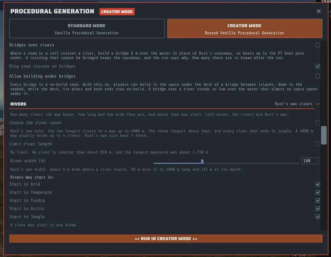
After a run the section says what happened, for example “Last run: the loop closed, with every crossing carried.” With Bridges over rivers on it also says what happened at the rivers, for example “Last run: 5 river crossings: 4 bridged, 1 kept as a causeway (it crosses the river too obliquely).” How many crossings a map has is only known after it is generated, because the rivers and the roads are generated too.
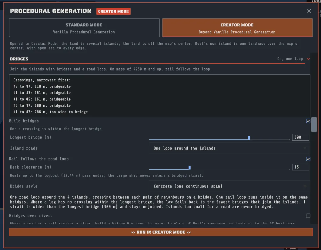
Where a bridge goes. Bridges join islands large enough for a road, and only those. The BRIDGES list shows every crossing between them, each judged against the longest bridge, and Creator builds the ones the roads need from it: one for each leg of the loop, or the fewest that join the islands. A strait wider than the longest bridge is left unbridged. Islets are never bridged, even one lying in a strait between two islands that are: it keeps what Rust gives its own small islets, which is no road and no bridge.
A bay mouth keeps its bridge site. On one island round a bay, the monuments are placed before the bridges, so Creator keeps the narrowest buildable crossing of the mouth clear for its bridge: no monument is placed with its edge within about 165 m of either end of that bridge or of its ramps, and no harbor or ferry terminal with its water within about 150 m of the span. A monument that would have stood there is placed elsewhere, as at any other spot it cannot take.
What a bridge looks like. By default it is a continuous concrete deck, as wide as the road on it, with parapets down both edges, rectangular piers to the seabed, and an abutment buried in each shore. Boats can pass between the piers. In Creator Mode each shore ends at the abutment in a line of tall rock cliffs either side of it, and the sea runs open under the deck right up to the abutment. Where another road passes a bridge end, the banks slope down to it and the cliffs stop short of it, and a road that comes down off the side of a ramp carries on down to the ground at a road’s slope, so no road is left in a cutting beside a bridge. The game’s ferry bridge piece is the other style, but only one piece fits on a crossing, so a long strait is refused in that style.
Where the road meets it. The road climbs a ramp on each shore and stops flush on the bridge, and the deck’s own surface carries the road markings across. Rust rebuilds every road’s mesh by pressing it onto the ground when a map loads, so a road cannot be drawn in mid-air over a strait: the deck IS the road across the water. Ramps vary a little in length and steepness from bridge to bridge, which is deliberate. The ramp’s banks stand at the game’s own road bank angle, so the steepest stretch of a tall bank shows rock, as a steep bank does in the game.
Rails can cross a bridge, because Rust treats a rail’s height as authored rather than pressing it onto the ground. Rust lays no rail network at all below 4250 m, so on a smaller map the rail settings change nothing, and the run says so in the generation log.
Every bridge is a no-build zone. The deck, both abutments and the ramps carry the game’s own no-building volume with a margin, from below the seabed to well above the deck, so nobody can build a base on the bridge or wall off its approach. The editor outlines these zones when VIEW > No-Build Zones is on (it starts off).
Building under a bridge. With Allow building under bridges on (a recipe sets
connectivity.buildUnderBridges to true), the zone over each bridge is cut so the space under the deck can be
built in, down to the seabed: the water and the ground under the span. What stays no-build:
- the deck, from 3 m under its underside up, with the same margin round it, so nobody can build on the deck or against its underside;
- each pier, with 3 m round it, so no base can stand against a pier or wrap one;
- each end of the bridge, the abutment and the ground within the full margin of it, and both ramps.
The game decides by the shape of what you are placing: anything that would reach into a no-build volume is refused, so a base under the deck stops one story short of it. A bridge built with the ferry bridge style keeps its whole zone, because the pieces of that style do not say where their piers stand. Where you can build in the water at all is the game’s own rule, the same as anywhere else on the map.
The space this opens is under a bridge between islands. A bridge over a river has its deck 6 m over the water, so the no-build volume under the deck reaches down to about 1.5 m over the water, and each end keeps its full margin: almost nothing under a river bridge can be built on.
Bridges over rivers. Where one of Rust’s roads or rails crosses a river, the game raises the ground under it
into a causeway two meters above the water, which dams the river: no boat passes it. Creator Mode can build a
bridge there instead. It is off by default, it needs no islands (it works on Rust’s own island), and a recipe
turns it on with connectivity.riverBridges set to auto. Each crossing then gets a concrete deck whose top
stands 6 m over the river, which leaves 4.5 m under it: enough for every boat up to the PT boat, and not for the
tugboat. The road climbs an embankment on each bank, stops flush on the deck and is split there, exactly as at a
bridge between islands; a rail is carried across on a narrow deck of its own. Rivers appear on maps larger than
2000 m, and rails on maps of 4250 m and larger.
Not every crossing can take a bridge, and one that cannot keeps Rust’s causeway. The generation log names each
crossing with its position and, for one kept as a causeway, the reason: it crosses the river too obliquely
(under 53 degrees, the shallowest angle Rust’s own roads cross at), it is a trail, it stands at the river’s
mouth, monument ground is in the way, the road ends at the bank, or another crossing stands too close for both
(a road and a rail that cross side by side each keep their causeway). connectivity.riverBridgeSites limits the
bridges to chosen crossings: list the spots as x:z, in meters from the map center, as the log prints them.
The ring road and the traveling vendor. The ring road is bridged like any other road, and so is the road
round a group of islands. A deck splits a road at its two ends, and Rust’s traveling vendor only drives a road
that is one closed loop, so on its own a bridged ring leaves the vendor no road. Creator therefore writes one more
road into the map, the vendor route: one closed road that follows the ring and runs across every deck, which
Rust counts among its main roads. Creator writes it at the end of the
generation and again each time you save, from the ring road and the bridges as they stand, and shows it read
only in the Paths tool. When the roads do not join into one loop across the decks,
the generation log says why and the server-ready check says the vendor will not spawn. To keep Rust’s causeway on
the ring road instead, which keeps the ring itself whole, set connectivity.riverBridgeRing to causeway; side
roads and rails still get their bridges.
One road and one rail around the islands
Section titled “One road and one rail around the islands”When your land is a group of islands, such as several islands around open water, two islands side by side, or one island curled round a bay, One loop around the islands lays one ring road around the whole group instead of a separate ring on each island. It crosses every strait it needs on a bridge (a bay mouth included), so you can drive all the way round without doubling back, and it is the map’s one main road, the way the single ring road is on an ordinary Rust map.
On a map of 4250 m or larger it also lays one rail loop around the group. The rail runs inside the road, crosses on the same bridges on its own lane of each deck, with a concrete divider between the rail and the road, and both lines straighten out as they reach a bridge so they arrive side by side rather than swerving onto the deck. The rail loop is the map’s main line, so the game’s own rules then run spur lines off it to the monuments that have a rail connection, such as the train yard and the tunnel entrances, and add their usual branches and sidings. In Creator Mode each spur line joins the main line in the direction it is already running, so it does not double back to meet it, unless joining that way would cross another spur line. Below 4250 m Rust lays no rail, so there is only the road loop.
The widest way round. The loop goes round the outside of the group, the widest way round the land, rather than cutting in to reach an island in the middle. An island the loop goes round, such as one in the middle of a ring of islands, keeps its own road (a ring, or a single road across it). If it is larger than the smallest island on the loop, one bridge joins its road to the loop, across its narrowest crossing to the loop that a bridge can span; that bridge carries the road only, never the rail. A smaller island in the middle gets no bridge.
Away from the shore. On each island the loop keeps well in from the coast, the way Rust’s own ring road keeps inland: it runs about a quarter of the way from the coast to the island’s middle, and never closer than 24 m to the water. On a narrow island it goes as far in as the land allows. The rail loop keeps its own place on the island rather than moving in with the road, so it does not crowd into the island’s middle. It stays inside the road with a wide gap between them, and where the ground at its place is too steep or built on for a railway, it moves toward the road instead of farther in.
When the loop does not fit. An island outside the loop that the loop cannot reach keeps its own road (a ring, or a single road across it if it is too small for a ring) and, on a large map, its own rail, and a bridge joins it to the rest. If the loop cannot be built, you get one ring per island joined by bridges (an island in the middle still gets only the one road bridge it would get with the loop, or none); BRIDGES says which.
Ring layout: one ring per island, or across each landmass
Section titled “Ring layout: one ring per island, or across each landmass”In Creator Mode the checklist shows a Ring layout choice under Road Ring. It decides how the Road Ring and Rail Ring rows lay their roads and rails:
| Choice | What it lays |
|---|---|
| One ring per island (the default) | Rust’s ring, fitted to each island that can hold one, as described above. |
| Across each landmass | On every large landmass, a ring road at the best open spot on it and a rail loop shaped to the land, with a line across the loop’s narrowest part. Smaller landmasses get no ring of their own. Rails are laid on maps under 4250 m too. |
Either way, islands joined by bridges in a closed loop still get the one road and one rail around the group. A row you untick lays nothing, whichever choice is set. In Standard Mode the choice is not shown and Rust’s own ring is laid.
Creator Mode also tidies the road network once it is laid: a road that ends in the middle of nowhere is cut back to the last road it meets, a road that joins another road ends on it, a road leaving a monument leaves along the monument’s own paving, and a road keeps off rivers and rails it does not cross.
RIVERS: how many, how long, how wide, where they start and where their rocks go
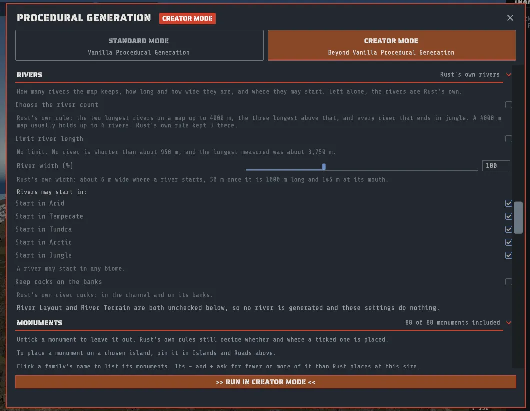
Section titled “RIVERS: how many, how long, how wide, where they start and where their rocks go”Rust decides a map’s rivers by itself. It walks downhill from the slopes inland, keeps the walks that reach the sea, and then keeps the two longest on a map up to 4000 m and the three longest above that, plus every river that ends in jungle. The RIVERS section adds four controls over that, and one switch for the rocks Rust scatters along a river. Left alone they change nothing, the section’s heading reads Rust’s own rivers, and the rivers are Rust’s own.
| Control | What it does |
|---|---|
| Choose the river count | Off by default, which is Rust’s own rule. Tick it and River count sets the most rivers the map keeps, from 0 to 10, counting the ones that end in jungle. The line under it says what a map of your size usually holds. |
| Limit river length | Off by default, which is no limit. Tick it and Longest river (m) sets a length from 1500 to 4000 m: a river longer than that is not kept. |
| River width (%) | From 50 to 200, where 100 is Rust’s own. The line under it gives the width in meters where a river starts, along its body and at its mouth. It never moves a river: the same rivers run the same courses. |
| Start in Arid, Temperate, Tundra, Arctic, Jungle | The biomes a river may start in. All five are ticked by default, which is anywhere. The last one cannot be unticked, and the line under the rows says so when you try. |
| Keep rocks on the banks | Off by default, which is Rust’s own river rocks: in the channel and on its banks. Tick it and no rock stands in a river’s channel, so a boat has clear water. It changes no river. |
After a run the section says what happened, for example “Last run: 3 of the 5 rivers asked for: 2 ran within 520 m of a river already kept.” The heading’s summary reads your settings back, for example Up to 5, at most 1500 m, 1.5 times wide.
An assistant, or a recipe you write, can set the same five things.
What to expect from each:
- The land decides how many rivers fit. Rust keeps every river at least 520 m from every other, so a count above what the land holds keeps fewer, and the run says how many it kept and why. Measured on Rust’s own islands, a 4000 m map usually holds up to 4 rivers, a 4500 m map 5 or 6 and a 5000 m map 8. Smaller and larger maps were not measured.
- A map of 2000 m or less has no rivers at all, whatever the settings: Rust looks for a river’s start from 250 m out from the center to 750 m short of the edge, and on a map that small there is no ground between the two. The section says “Maps of 2000 m or less have no rivers.” and its controls are grayed.
- Asking for the number Rust would keep is not the same as leaving the count alone. Your count is a total, so a long river can take the place of a shorter one that ends in jungle. Only the default gives Rust’s own rivers.
- A shorter limit usually gives more rivers, not fewer. When a long river is turned down, a shorter one from further down the same valley can take its place. A limit above 4000 m would limit nothing: the longest river measured was about 3,750 m. No river is shorter than about 950 m.
- Width is the same river, wider or narrower. One of Rust’s rivers is about 6 m wide where it starts, about 50 m once it is 1000 m long, and about 145 m at its mouth. At twice the width that is about 12 m, 100 m and 290 m. Above twice, rivers begin to run into their own bends, so the control stops there. A road or a rail that crosses a wider river has further to go, so look at the crossings after a run with wider rivers.
- The starting biome is where a river begins, not where it runs. Most rivers end in a different biome from the one they start in, so choosing jungle does not give you a jungle river. Choosing one biome usually gives fewer rivers than the map could hold.
- Keep rocks on the banks leaves rocks out; it adds and moves none. Rust scatters one kind of rock along a
river, in the water and beside it. With the switch on, the ones that would stand in the channel are left out,
and every rock that stays is the rock Rust places, where Rust places it. A large rock on the bank can still
reach over the water’s edge; the middle of the channel is what stays clear. It does nothing while
River Rocks is unticked in the component list, and the section says so and greys the switch then. It
still works when the river rows are unticked (a map that keeps its own rivers), so you can re-scatter the
river rocks and keep the channel clear.
-noriverbankrockson the command line turns it off for a scripted run.
These settings act on rivers that are generated, so they do nothing while the River Layout and River Terrain components are both unchecked, and the section says so.
MONUMENTS: choosing what may be placed
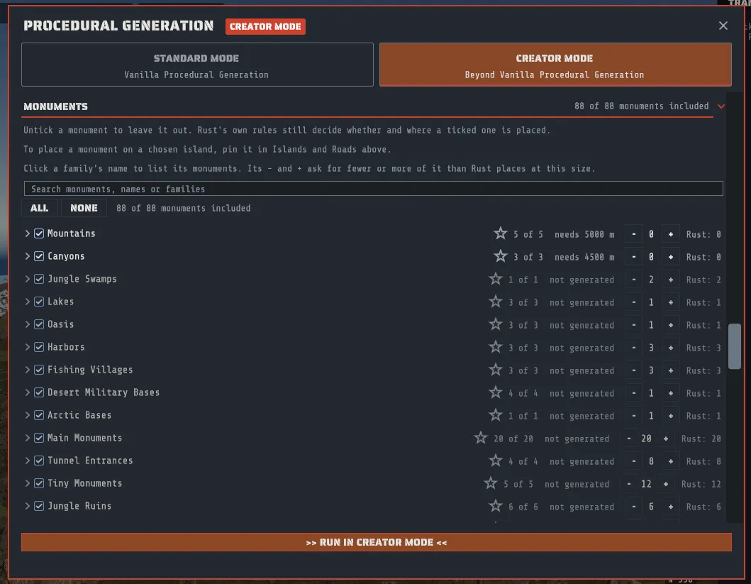
Section titled “MONUMENTS: choosing what may be placed”Every monument your Rust content carries is listed, grouped by the family that places it, in the order Rust places them: from mountains, canyons and lakes, through harbors, the main monuments by size and the tunnel entrances, to caves, the underwater labs, the offshore oil rigs and lighthouses. Train tunnel pieces are not monuments and are not listed.
Each family is one line, closed to start with, so the whole list fits on one screen. A family’s line carries, left to right: an arrow that opens it, a checkbox for the whole family, the family’s name, how many of its monuments are ticked (3 of 3), and its count, - 3 + with Rust’s own count beside it (Rust: 3). Click the arrow or the family’s name to show its monuments as checkboxes, two or three to a row depending on how wide the panel is; click again to hide them. Creator remembers which families you left open until you close the app. Hover a family’s name to see what Rust places of it at this map size.
- Ticked means eligible. Rust’s own placement rules still decide whether it lands and where: biome, terrain, spacing, the map size, and how many of that family the map gets.
- Unticked means never placed. That is all it means: it does not make another monument more likely to appear in its place.
- A family’s checkbox includes or leaves out every monument of that family at once. It shows a dash when some are ticked and some are not; clicking a dash ticks them all.
- The search box matches a monument’s name, its prefab path and its family. While you type, every family
with a match opens by itself. ALL and NONE apply to what the search shows, so searching
airfieldand pressing NONE leaves out just the airfield. The total at the top, and on the section’s heading while it is closed, reads k of N monuments included. - Two monuments that share a name in Rust are told apart by the end of their prefab file name: the two harbors read Harbor 1 and Harbor 2, and the two smaller fishing villages Fishing Village B and Fishing Village C. The assistant’s monument list uses the same names, and a recipe that says Harbor still means both harbors.
- A monument marked x2 or x3 is one Rust’s pool carries more than once, so its family draws it more often. A family marked needs 4500 m (or another size) is one Rust skips on a map this small.
- A family whose component is unchecked in the checklist below is shown dimmed and marked not generated; hover it for why. On a map that already has monuments those components start unchecked, so the map keeps its own.
How many of each family. On each family’s line, the number between - and + is how many of that family the map asks for, with Rust’s own count for this map size beside it (Rust: 3). - and + ask for one fewer or one more, and DEFAULT, which shows only while you have asked for a different number, puts the family back on Rust’s own count.
- Rust’s own count is what a Rust server places on a map this size: the family’s target for the size, or one of each of its ticked monuments for a family that places each at most once (Harbors, Main Monuments, Tiny Monuments and the like). Unticking monuments lowers it for a one-of-each family.
- Fewer caps the family at your number, and 0 leaves the whole family out.
- More draws extra copies from the family’s own ticked monuments, in the proportions Rust already uses, so asking for six Harbors on a map whose Rust count is two repeats both harbors. Every one of Rust’s placement rules still applies to every copy: how far apart two of the same family must stand, the ground each needs, the coast, the biome. A family that cannot fit what you ask places fewer, and a crowded family on a small map can end up with its usual number or less.
- The offshore oil rigs are not counted here: they have their own controls, OIL RIGS, below the families.
- Combined with the ticks: the count applies to the monuments you left ticked, so ticking only Launch Site and asking Main Monuments for three asks for three Launch Sites, which Rust keeps well apart. Combined with pins: an island’s share of a family is its share of the count you asked for.
The GENERATE confirm says how many families you changed (Monument counts changed: 2 families.). Creator’s server-readiness check warns, rather than refusing, when a count is more than the family could fit on the map at all, when a family is not placed at this map size, and when every monument of a family is unticked.
Leaving a monument out works the way a Rust server’s own blacklist of that one prefab does: the family draws from the monuments that are left, every other family is untouched, and a family with nothing left places nothing. Two combinations change how the map plays, and Creator’s server-readiness check warns about them rather than refusing: leaving out every tunnel entrance leaves the map with no train tunnel network, and leaving out both Outpost and Bandit Camp leaves it with no safe zone.
The list appears once your Rust content has loaded.
To place a monument on a chosen island, pin it in ISLANDS AND ROADS, above. The list only says what may be placed.
Oil rigs: how many, and where
Section titled “Oil rigs: how many, and where”Rust places one small and one large oil rig on a ring around the map: 300 to 350 m beyond the map edge, at least 1000 m apart, on a map of any size. It never puts one off the side of the map that holds its lowest tier. Below the families, OIL RIGS lets you ask for more, fewer or none of each, and place rigs on that ring yourself.
Screenshot: Creator Mode’s OIL RIGS block in the MONUMENTS section: the small and large rig counts at Rust’s own, the ring’s capacity and PLACE RIGS. (
images/procedural-oil-rigs.png)
How many. Small oil rigs and Large oil rigs each show, between - and +, how many of that rig the run places by Rust’s own rule. Rust’s own is one of each. 0 places none, the number stops at 10, and RUST’S OWN, which shows only while you have asked for a different number, goes back. Every rig follows the ring’s rules, so a small map fits fewer than you ask for: the line under the two numbers says how many rigs the ring of this map has room for, and after a run the last line of the block says how many were placed and why any were left out.
Where. PLACE RIGS opens a picture of the map from above, north at the top, with the ring drawn around it.
- Press ADD SMALL RIG or ADD LARGE RIG. The rig appears on the ring, clear of the others.
- Drag it along the ring. It cannot leave the ring. While you drag, a circle shows how far apart Rust keeps two rigs, and two rigs closer than that turn orange. On a map whose own terrain the run keeps, that distance is measured on the sea floor at this map’s edge, as the run measures it.
- Type a Yaw (degrees) to turn it. Left at auto, it faces the way Rust would turn a rig at that spot. A yaw that is not a number is refused, and the line under the picture says so.
- Press REMOVE RIG to take one off again.
A rig you place stands exactly there. The rigs you did not place are placed by Rust’s own rule and keep clear of yours. Once you place a rig of one kind, the run places no other rig of that kind unless you ask for some with its number.
- A placed rig still has to pass Rust’s own check for its spot. One that stands off the side of the map that holds its lowest tier is left out, and the last run line says so. Which side that is depends on the seed. Once the open map has its tiers (after a run, or on a map you opened), the picture shades the stretches of the ring off that side.
- Unticking the Underwater Labs component leaves out the oil rigs too, because the same component places them. To keep the labs and have no rigs, set both rig numbers to 0.
- Unticking a rig in the Offshore family leaves that rig out, whatever its number says.
- Dragging a rig changes the panel, not the map, so it is not an undo step. The generation is.
The GENERATE confirm names the rigs you asked for (Oil rigs: 2 small, 1 large, 1 at exact spots.). An assistant can set the same numbers and spots; a spot off the ring is refused with the nearest spot on it.
Custom monuments: your own packs, placed by the generation
Section titled “Custom monuments: your own packs, placed by the generation”Below the oil rigs sits one more family, Custom. It places a pack you saved in the prefab workspace (any pack in your custom prefab library) as a monument of its own. To add one:
- Choose the pack under Pack and press ADD PACK. Pressing it again for the same pack asks for one more.
- Set its rules (below). The - and + beside its name set how many; REMOVE PACK takes it out.
- Generate in Creator Mode. Custom monuments are Creator Mode only: a Standard Mode run never places one.
Each custom monument has six rules:
| Rule | What it does |
|---|---|
| How many | How many of this pack the map asks for (0 to 20). A map with no room for all of them places fewer, and the section’s last line says how many were placed. |
| In Arid, In Temperate, In Tundra, In Arctic, In Jungle | The biomes it may stand in, read at its center. All five ticked means any biome. |
| Min distance (m) | The least distance from its edge to any other monument, Rust’s own or custom (200 m by default). |
| Steepest ground (deg) | The steepest ground it may be placed on, measured under its whole footprint before it is placed (20 degrees by default). |
| Land only | Keeps it on dry land, clear of the sea, lakes, rivers and swamps (on by default). |
| Roads | How it meets the roads. Beside a road places it beside a road that passes it (the default for a pack with no entrances). Away from roads places it where a monument goes instead. Connect a road or rail to its entrances is offered when the pack has entrances marked on it, and is the default for such a pack. |
Under Roads, a line says what the pack offers: its entrances by kind (for example Entrances: 1 road, 1 rail), or that it has none and where to mark one.
It also always stays inside the map with its blended edge, clear of every bridge the run builds, and clear of every rail line: its blended edge stays at least 20 m from any track and 72 m from the end of one (where a tunnel entrance can stand). Its blended edge never reaches a river either, even with Land only off.
It is never placed on a small islet.
A custom monument is only placed on dry land.
On a small map there may be no room. Rust’s own island covers only a small share of a 1000 m map, and a pack needs its footprint plus the 24 m ring on dry ground, clear of the edge and of other monuments, so a large pack can still find no room there. When a pack places none, the section’s last line says so. For large packs, generate 2000 m or more.
Where it goes. A custom monument set to Away from roads is placed like one of Rust’s own monuments, before the roads, and everything placed after it keeps clear of it. One set to Beside a road is placed after the roads are laid, beside one of them, the way Rust places its own roadside monuments (gas stations, supermarkets): facing the road with its front edge 16 m from the road’s center. The road passes it; no road is moved for it, no road runs through it, and no road ends at it. A road is built to a custom monument only through an entrance you marked on the pack (next paragraph). If there is no spot beside a road that meets its rules (no road on the map, or none with room beside it), it is still placed clear of roads, and the note under the pack in the panel says no roadside spot; placed clear of roads.
Roads and rails to its entrances. A pack with entrances marked on it is connected: Rust’s own road, trail, rail and powerline layout builds to each one, as it does for Rust’s own monuments. A road or a trail ends on its entrance. A rail spur starts at its entrance and leaves the way the entrance faces. A powerline ends near its entrance, not on it. Rails exist only on maps of 4250 m and larger, so a rail entrance connects nothing on a smaller map. A pack whose only entrances are rail entrances is then not connected at all: it is placed as a pack with none, beside a road or away from roads as its Roads choice says, and Connect a road or rail to its entrances is not offered for it at that size.
Each entrance needs open, dry ground in front of it: 30 m no steeper than 20 degrees for a road or a trail, a 60 m run no steeper than 30 degrees for a rail. An entrance that opens onto a walled-in pocket is refused.
Rust’s layout has the last word. Like Rust’s own monuments, an entrance can be left without a road when the
route finds no way through. That is reported, never an error: the note under the pack says which entrance. Try
another seed, or move the entrance to a more open side of the pack. An entrance that breaks one of the
pack rules is left out; the rest still
connect. To place a pack that has entrances without connecting it, choose Beside a road or
Away from roads under Roads (in a recipe, connect=no on its entry).
An assistant can read your library with the list_packs tool, which lists
each pack’s name, its size, its piece count and its entrances by kind, and can then add one to the recipe by name.
Its ground. The pack’s own terrain blends into the surrounding land. A pack with no terrain of its own gets a flat pad under it. Its ground textures blend over the same ring, and its topology (marked as a monument) and any holes it carries are written inside its footprint. Inside the footprint, natural ground (grass, sand, snow) is the map’s own, so the pack fits every biome it lands in; paths, pads, gravel and rock stay as you painted them. To keep a painted lawn or beach, place the pack by hand.
What a plain server shows. Every ordinary prefab in the pack appears on any server, like any placed prefab, and the pack’s name is written on the in-game map at its center, which every player sees. What a pack carries beyond ordinary prefabs (building blocks, wiring, loot, NPC spawners and volumes) needs the Creator server extension, as it does for any custom prefab.
The recipe remembers the pack. Generating again places the same pack. If you changed the pack since, the panel says so. A pack that is no longer in your library is left out and named.
Swap: your own pack where Rust puts a monument
Section titled “Swap: your own pack where Rust puts a monument”Under Custom, the Swap block exchanges a monument Rust places for one of your packs, in the same spot. Pick the monument under Monument to swap, pick the pack, and press ADD SWAP. Each swap has its choices, Use the pack’s ground (off: the generated ground stays), Fill the monument’s holes (on) and, on a monument with a way down to the train tunnels, Keep the train tunnel entrance (on: its stairwell is placed again), and a Map name that is left empty to keep the monument’s own name on the in-game map.
The map is generated for Rust’s monument first, and the exchange happens at the very end. Rust picks the site, flattens the ground, keeps every other monument its usual distance away, and builds the roads, trails, rails and powerlines to the monument’s own entrances. Only then is the monument taken out and your pack put where it stood. That is why the connections are kept: nothing that built them is changed, and a road still ends where the monument’s gate was. Build the pack with that in mind.
- Every placed copy is swapped. A swap names a monument, not one copy of it, because the recipe is written before the generation decides where each copy lands. To swap one copy of several, generate without the swap and use Swap For Pack on the map.
- Rust still decides whether the monument lands at all. A swap never forces a monument onto a map too small for it or into a biome it does not belong to. When the monument was not placed, the note under the swap says so.
- None of the monument’s own content comes with it. Its loot, NPCs, puzzles, doors, radiation and safe zone leave with Rust’s prefab; the pack brings its own. The full list, monument by monument, is what Swap For Pack shows on the map before you confirm.
- A pack larger than the monument’s bounds is allowed, and the note says by how much, since generated rocks, trees and roads may stand in that ground.
The recipe remembers each swap by the monument, the pack’s name and a fingerprint of the pack’s files, exactly as it remembers a custom monument. Undoing the generation takes the swaps back with it.
TROPICAL: the Tropical biome
Section titled “TROPICAL: the Tropical biome”The TROPICAL section gives a run the Deep Sea’s tropical look. Its two checkboxes, Semi-Tropical and Fully Tropical, are both off by default and only one can be on at a time; with both off the run writes nothing tropical and Arid stays desert.
- Semi-Tropical makes the islands you tick, and if you choose it the Arid band Rust’s own generation places, Tropical as the run finishes: their ground is saved as Arid under a Tropical layer, their beaches use Sand rather than the Snow slot, and they are dressed with the Deep Sea islands’ own palms, figs, bushes and rocks.
- Fully Tropical puts the whole map on the tropical look and dresses the land where Arid is the main biome.
Prop density is a percentage of what the Deep Sea islands carry (100 % by default). The generation undo takes the Tropical ground and the props back with the rest of the run. What each server shows, and the palettes themselves, are on Tropical biome.
DEEP SEA ISLANDS: the Deep Sea’s islands in your sea
Section titled “DEEP SEA ISLANDS: the Deep Sea’s islands in your sea”Creator Mode’s last section lays out the four tropical islands of Rust’s Deep Sea (Horseshoe, Blob, Round and Line) in the open sea of the map you generate. It is off by default. Tick Lay out Deep Sea islands, choose the Island count (6 by default, the number the game’s own Deep Sea opens) and which of the four islands the layout may use; each is used once before any repeats.
Each island is written into the map exactly as the Island Stamp writes one: its own height, ground textures and topology, with its palms, cliffs and dwellings on top. Because the island is the map’s own ground and art, it works on any server and no Deep Sea close removes it. The layout keeps every island:
- in open water at least 10 m deep, so it never merges into your coast;
- clear of every monument and every bridge;
- inside the map, with its land at least 250 m from the map edge, where Rust needs open sea;
- at least 600 m from the next Deep Sea island, the spacing the game’s own Deep Sea uses.
A map with little open sea may fit fewer islands than you asked for; the section’s last line says how many were placed and why any were not. The islands keep the Arid ground the game gives them, so with the Tropical biome off they show desert sand and rock; turn on Semi-Tropical or Fully Tropical in the section above for the tropical look. The generation undo takes the islands back with the rest of the run.
An assistant, or a recipe you write, can also put an island at an exact spot, written as island@x:z or
island@x:z:yaw, for example 2@1200:-800:45 (meters from the map center, turned 45 degrees). A spot that
breaks one of the rules above is left out, and the run says why.
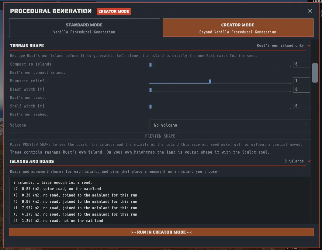
TERRAIN SHAPE: reshaping Rust’s own island
Section titled “TERRAIN SHAPE: reshaping Rust’s own island”When LAND is Rust’s own island, the TERRAIN SHAPE section reshapes that island before anything else is generated. Rust’s generator takes no such setting, so this is Creator Mode only, and with every control left alone the island is exactly the one Rust makes for the seed. On a heightmap you bring the section is grayed out: that land is yours, and the Sculpt tool shapes it.
| Control | Range | What it does |
|---|---|---|
| Compact to islands | 0 to 1, 0 is Rust’s own | Breaks the compact island up: the lowlands flood, and the largest island is cut along its own valleys into a group of islands. At 1 about half the land is left. |
| Mountain relief | 0.25 to 2, 1 is Rust’s own | Flattens or exaggerates the hills. The coastline does not move. |
| Beach width (m) | 0 to 80, 0 is Rust’s own | Lowers the land beside the sea to a gentle beach of this width. |
| Shelf width (m) | 0 to 200, 0 is Rust’s own | Raises the seabed beside the coast to a shallow shelf of this width. Shelf depth (m) (5 to 12, 8 by default) appears once there is a shelf. |
| Volcano | No volcano, The highest mountain, The map’s center, A point I choose | Raises one volcano, and shows its sizes once it is on. |
PREVIEW SHAPE shows what the settings make before you generate anything, and with every control left alone it shows Rust’s own island for the map’s size and the seed in the panel: a small map with the deep sea dark, shallow water blue, the beach amber, land green, land too steep for a road gray and the volcano red, each island that is large enough for a road numbered, and a line across each strait between those islands, light where a bridge can be built and red where it cannot. A key under the picture puts a swatch of each color beside its name, and the picture of your own land in LAND carries the same key. Under it the section says how much land is left, how many islands are large enough for a road, how many straits can take a bridge, where the volcano stands (or why it could not be placed), and how the steep land and the beach changed. The preview is made when you press the button, and by itself a moment after you stop moving a control. Making it works out the whole island, so the section says “Measuring the shape” first and the panel waits a moment. It reads the same island the run will shape, so the islands it shows are the islands you get.
What to expect from each control:
- Compact to islands is a degree, not a number of islands. The islands are Rust’s own highlands, so how many you get depends on the seed and the map size, and the preview counts them. A 4000 m map gives about two islands a quarter of the way along and about four at the far end; a map under 3000 m has one island to work with, so there the setting mostly floods the lowlands.
- The straits are made to be bridged. A cut strait is 160 m wide and 6 m deep. A strait over a flooded valley can be deeper than a bridge’s piers reach, and the preview says how many are; a shelf about 150 m wide brings them back within reach.
- BRIDGES follows the preview. Rust’s own island alone has nothing to bridge. Once the island is broken up, the BRIDGES section lists the preview’s straits, and its switch is on by default when a bridge can span one, exactly as it is for a heightmap with islands. Each island gets its own road and its own share of the monuments. A shape that leaves one island large enough for a road (relief or beach alone, say) keeps Rust’s own road ring, and on a map of 4250 m or larger its rail ring, unless that island curls round a bay whose mouth a bridge can span, which takes the one loop round the bay and across its mouth. Monument pins and Semi-Tropical islands still name the islands of a heightmap you bring; they are not offered on a reshaped island.
- The biome follows the height. Rust decides the biome from the land it is given: lower land is warmer and higher land is colder, so a high relief grows the snow and a flooded island loses some of it.
- High relief costs building room. At 1.5 about twice as much land is too steep for a road as on Rust’s own island; at 0.5 and under, the beach spreads inland and the forest and field shrink.
- A wide beach is flat land taken from the hills. An 80 m beach lowers about a third of the land.
The volcano. Choose where it stands: The highest mountain (the highest ground that has room for the whole cone), The map’s center, or A point I choose (East of center (m) and North of center (m)). Its sizes are Base radius (m) (150 to 600, 400 by default), Cone height (m) (60 to 300, 200 by default; the rim above the ground the cone stands on), Crater radius (m) (between 0.15 and 0.3 of the base radius, and it follows the base as you move it), Crater depth (m) (10 to 60, 40 by default) and Lava field radius (m) (0 for none).
- It is ground only. The cone is part of the terrain, its steep flank is painted rock by the game’s own cliff rule, and the crater and a few tongues down the flank are a lava field drawn with the dark ground textures. There are no crates, ore, smoke or glowing lava.
- No monument is placed on it. The cone is marked as a mountain, and Rust’s own rules keep monuments off mountains.
- A tall cone turns cold. Rust decides the biome from the height, so a cone whose rim stands well over 100 m gets snow and the Arctic biome on its upper half, on a desert island too. A cone under about 100 m keeps the biome it stands in.
- It needs room. The whole base has to fit on land and inside the map. If it does not, the preview says so before you generate, and a run goes ahead without the volcano and says why. A broken-up island has less room: a 300 m base still fits on every 4000 m and larger map measured, a 400 m base on about two in three.
Screenshot: a generated volcano from above: the cone in rock, the crater and its lava tongues, and no monument on it. (
images/procedural-volcano.png)
An assistant, or a recipe you write, sets the same controls as
terrain.relief, terrain.fragmentation, terrain.beachWidthMeters, terrain.shelfWidthMeters and
terrain.shelfDepthMeters, and the volcano as volcano.mode (off, highest, centre or at, with volcano.x
and volcano.z in meters from the map center), volcano.baseRadiusMeters, volcano.heightMeters,
volcano.craterRadiusMeters, volcano.craterDepthMeters and volcano.lavaRadiusMeters.
Cliffs in Creator Mode
Section titled “Cliffs in Creator Mode”In Creator Mode the cliffs are placed before anything else, and the monuments, roads and rails are laid out around them, so none of them cuts into or buries a cliff. Rivers run where Rust’s own rivers would: a river that meets a cliff cuts a valley through it, and the cliff makes way. On a map from Crucible Heightmap, rivers keep clear of its lakes. This replaces Rust’s own Coastal Cliffs and Cliffs Hills rows whenever either is ticked; untick both and the map gets no cliffs. Standard Mode keeps Rust’s own cliffs. The cliff generation was made by Drizzza for Crucible Heightmap and brought into Creator Mode. On a map exported from Crucible Heightmap with its cliffs left out, it places the same cliffs Heightmap would have placed.
Two rows at the bottom of TERRAIN SHAPE shape it, on any land:
| Row | Default | What it does |
|---|---|---|
| Flatten peaks to the cliff tops | On | Lowers a peak that stands above the cliffs around it to the tops of those cliffs. Off keeps every peak as it is. |
| Small rocks around the cliffs | On | Scatters small rock formations around the cliffs. Off places the cliffs without them. |
A recipe sets them as cliffs.keepPeaks and cliffs.noSmallRocks (both false by default).
What Creator Mode keeps
Section titled “What Creator Mode keeps”Reopening a Creator-made map restores the same settings. Undoing the run puts the previous map and its settings back.
Driving generation from an assistant
Section titled “Driving generation from an assistant”If you have connected Claude Desktop or Claude Code, generation is one of the things you can ask for in words instead of filling in the form. A request becomes a recipe holding the size, the seed and the rest of the settings above, Creator shows you what it plans to do, and nothing runs until you accept it.
A recipe is in Standard Mode or Creator Mode, the same as the panel. Asking for anything only Creator Mode does (your own heightmap, monuments left out, monument counts, pins, bridges, the river settings) switches the recipe to Creator Mode, and the assistant is told so in the same answer. The confirm card for a Creator Mode generation carries the CREATOR MODE badge and opens with the panel’s own sentence, so the two can never disagree. The details are on the Claude Desktop page.
A run on this map’s terrain keeps the map, the way the panel does. When the recipe’s land is this map’s
terrain (terrain.source set to loaded) and the run is at the open map’s own size, Creator carries the whole
open map into the run: its height and water, its biome, topology and ground textures wherever the recipe does not
turn that row on, and every placed prefab except those of the rows the run generates again, so a regenerated
row replaces its old prefabs instead of doubling them. Lava, water bodies and anything you placed by hand stay.
On a map made in RustEdit, the wiring, loot, vending and NPC data it carries for the prefabs that stay keep
working on a server after the run.
Choosing this map’s terrain sets the recipe’s size to the open map’s own size and the assistant is told so; if
you had already picked another size, the run rebuilds the land at that size and keeps only its height.